Series OSS Code No. 64/1
GEOGRAPHY (Theory)
Tine allowed : 3 hours Maximum Marks: 70
General Instructions :
(i) There are 26 questions in all.
(ii) All questions are compulsory.
(iii) Marks of each question are indicated against it.
(iv) Questions number 1 to 10 are very short answer questions carrying 1 mark each. Answer to each of these questions should not exceed 20 words.
(v) Questions number 11 to 20 are short answer questions carrying 3 marks each. Answer to each of these questions should not exceed 80 words.
(vi) Questions number 21 to 25 are long answer questions carrying 5 marks each. Answer to each of these questions should not exceed 150 words.
(vii) Question number 26 is related to identification or locating and labelling of geographical features on maps.
(viii) Outline maps of the World and India provided to you must be attached within your answer-book.
(ix) Use of templates or stencils for drawing outline maps is allowed.
1. Name any two areas of high latitudes in the world, where gathering economic activity is practised.
2. Name the type of most of the great ports of the world.
3. Categorise the international trade in two types.
4. Which class of cities has the largest number of towns and cities in India ?
5. Which sector (economic activity) uses most of the surface and ground water in India ?
6. Name the place of Maharashtra, where an atomic power station is located.
7. Name where the iron and steel plant is located in Chhattisgarh.
8. Which country is the largest trading partner of India ?
9. Which export commodity of India has the highest value ?
10. Which is the main source of environmental pollution in India ?
11. What type of rural settlements are generally found in the fertile alluvial plains of India ? Mention any two features of such type of settlements. 1+2=3
12. Classify industries of the world on the basis of ownership into three groups. State the main feature of each, group.
13. How does technology loosen the shackles of environment on human beings ? Explain with examples. 3x1=3
14. Which are the two factors affecting tourism in the world ? Explain each factor with example.
15. Explain any three features of underground mining method used in different countries of the world. 3x1=3
16. How is the difference in national resources a basis of international trade ? Explain with three examples. 3x1=3
17. How is the degradation of cultivable land is one of the serious problems in India ? Explain in any three points. 3x1=3
18. How has the introduction of Indira Gandhi Canal irrigation in the dry lands of Rajasthan influenced the environmental conditions of the region positively ? Explain in any three points. 3x1=3
19. Explain the three types of changes that have affected land use in India. 3x1=3
20. How do slums develop in India ? Explain any four miserable conditions the residents of slum areas. 1 +2=3
21. Explain the meaning of rural settlements. Describe any four problems related to rural settlements of the world. 1+4=5
22. What is the importance of air transport ? Describe any four characteristics, of air transport system of India. 1+4=5
23. What is the meaning of density of population ? Explain with examples four geographical factors influencing the distribution of population in the world. 1+4= 5
What is the significance of inland waterways ? Explain the three factors responsible for the development of inland waterways in the world. 2
25. Study the given diagram, showing Intra State Migration Streams in India and answer the questions that follow : 1+2+2=5

Migration Streams
Intra State Migration by Place of Last Residence Indicating
Migration Streams (Duration 0 9 years), India, 2001
(25.1) Which migration stream shows the highest number of migrants in both male and female categories ?
(25.2) Why does this migration stream show the highest migration in both the categories ? Give one reason for each.
(25.3) Why do female migrants dominate in all the four streams of migration ? Give two reasons
Note : The following question is for the Blind Candidates only, in lieu of Q. No. 25.
What is migration ? Explain any four factors responsible for the migration of people in India. 1+4=5
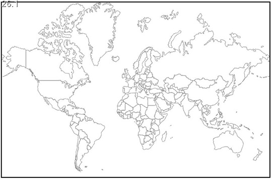
26. (26.1) In the given political outline map of the World, Identify and mark the following features and write their correct names against each of them: 4 x 1/2 = 2
A. The country having the largest population in Europe
B. A major seaport
C. A major airport
D. A mega city

(26.2) In the given political outline map of India, locate and label the following with appropriate symbols : 3x1=3
(i) The State having lowest density of population
(ii) The Software Technology Park located in Jammu and Kashmir State
(iii) The major seaport located in Kerala

Outline Map of India (Political)
Note: The following questions are for the Blind Candidates only, in lieu of Q.No. 26
(26.1) Which country has the largest population in Europe ?
(26.2) Name the mega city of Argentina.
(26.3) Which state of India has the lowest density of population ?
(26.4) Name the Software Technology Park located in the state of Jammu and Kashmir.
(26.5) Which is the major seaport in the state of Kerala ? 5x1=5